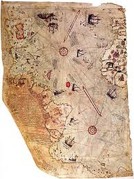
In 1929, a German theologian working in the archives of the Topkapı Palace in Istanbul came across a fragment of a map drawn on gazelle hide. It had been produced in 1513 by an Ottoman admiral named Piri Reis, who noted in his annotations that he had compiled it from a collection of earlier source maps, including one that he attributed to Christopher Columbus. The map showed the Atlantic Ocean, the western coast of Africa, the eastern coast of South America, and — running along the bottom — a landmass that, when examined carefully, appeared to correspond with suspicious accuracy to the coastline of Antarctica. Antarctica was not officially discovered by European explorers until 1818, three centuries after the Piri Reis Map was drawn.
The map was examined in the 1960s by Charles Hapgood, a professor of the history of science at Keene State College in New Hampshire. Hapgood spent years studying the map and concluded that its depiction of Antarctica was not coincidental or approximate but accurate — that it showed the continent’s coastline as it would appear beneath the ice that currently covers it, which is to say as it last appeared above water approximately 6,000 years ago. He further concluded that the map’s overall geometry was based on a spherical projection system not developed in European cartography until the 16th century, and that the source maps Piri Reis described must have been compiled by a civilisation with both knowledge of the full globe and cartographic technology far in advance of anything documented in the historical record.
The Hapgood Thesis and Its Critics
Hapgood’s analysis was controversial from the outset. Mainstream cartographic historians have raised several objections. First, that the identification of the bottom landmass as Antarctica is not unambiguous — the map’s southern continent could equally be a distorted representation of South America’s southern tip, or a standard cartographic feature of medieval and Renaissance maps that conventionally included a large southern landmass based on theoretical symmetry rather than actual survey. Second, that the “accuracy” of the Antarctic coastline correspondence depends on selective alignment and can be made to disappear with different projection choices. Third, that the map’s overall geometric sophistication does not necessarily imply the source maps were ancient — Piri Reis had access to Islamic and Venetian cartographic traditions that were more advanced than the European maps typically used for comparison.
These are substantive objections. But they do not fully resolve the anomaly. The southern continent on the Piri Reis Map does show features — including what appears to be a river system flowing into bays on the sub-ice coastline — that go beyond the conventional southern continent included for theoretical reasons. Charles Hapgood’s maps were examined by cartographers at the US Navy Hydrographic Office, who confirmed that the projection system used was consistent with a polar azimuthal equidistant projection, centred on Cairo — a sophisticated mathematical choice that implies a comprehensive survey from a fixed reference point. The question of how Piri Reis’s source maps came to include this information has not been satisfactorily answered by conventional cartographic history.
The Bigger Question
For researchers in the ancient civilisation tradition, the Piri Reis Map is one piece of a larger pattern: a set of anomalous artefacts — maps, monuments, texts, and astronomical alignments — that implies a level of geographical and mathematical knowledge in the ancient world far exceeding what the official timeline of human development admits. If a culture possessed a complete map of the globe before the last polar ice cap formed over Antarctica, that culture existed before approximately 4000 BCE — and it possessed both the navigational capability to survey the globe and the cartographic capability to represent a sphere on a flat surface. Neither of those things is supposed to have existed in anything like that form until the European Renaissance.
The conventional response — that the Piri Reis Map’s anomalies are the result of accumulated cartographic error, creative distortion, and the insertion of theoretical southern landmasses — is not implausible. But it is also not fully satisfying, because it requires dismissing a specific set of correspondences with the actual sub-ice Antarctic coastline that cannot be entirely attributed to chance. The map continues to attract serious attention from cartographers, historians, and alternative researchers for the same reason that other apparently anomalous artefacts do: because the gap between what it shows and what should have been known in 1513 has not been convincingly closed. Until it is, the Piri Reis Map remains one of the most provocative documents in the history of cartography.
Watch
The Piri Reis Map — Ancient Knowledge of Antarctica
Watch
Maps of the Ancient Sea Kings — Charles Hapgood and the Cartographic Mystery
Recommended Reading
Maps of the Ancient Sea Kings — Charles Hapgood (1966)
The foundational analysis of the Piri Reis Map and other anomalous cartographic documents — Hapgood’s argument that they derive from a source civilisation with comprehensive knowledge of the globe.
View on Amazon →Fingerprints of the Gods — Graham Hancock (1995)
Hancock builds extensively on Hapgood’s cartographic research in constructing the case for a lost civilisation — the Piri Reis Map is one of the key exhibits in his argument.
View on Amazon →Technology of the Gods — David Hatcher Childress (2000)
Childress examines the full range of evidence for ancient advanced technology, including cartographic knowledge — placing the Piri Reis Map in the broader context of a lost technical civilisation.
View on Amazon →